
Fitxategi:Enewetak Atoll - 2014-02-10 - Landsat 8 - 15m.png

Aurreikuspen honen neurria: 592 × 599 pixel. Bestelako bereizmenak: 237 × 240 pixel | 474 × 480 pixel | 759 × 768 pixel | 1.012 × 1.024 pixel | 2.023 × 2.048 pixel | 2.841 × 2.876 pixel.
Bereizmen handikoa ((2.841 × 2.876 pixel, fitxategiaren tamaina: 5,72 MB, MIME mota: image/png))
Fitxategi hau Wikimedia Commonsekoa da. Hango deskribapen orriko informazioa behean duzu. |
Laburpena
| Deskribapena |
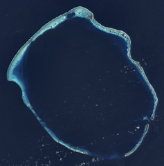
English: Composite "true color" multispectral satellite image of Enewetak Atoll.
NASA Landsat 8 OLI bands used were 4 (red), 3 (green), 2 (blue). Pan-sharpened with band 8. Manual color balance. Projection: UTM (zone 57), WGS84. Imagery courtesy NASA/USGS. |
| Data | |
| Jatorria | NASA/USGS Landsat satellite image GeoTIFF archive, http://glovis.usgs.gov |
| Egilea | NASA |
| Beste bertsioak |

| Kameraren kokapena | | Irudi hau eta gehiago beraien kokapenekin hurrengo lekuetan: OpenStreetMap |
|---|
Lizentzia
| This file is in the public domain in the United States because it was solely created by NASA. NASA copyright policy states that "NASA material is not protected by copyright unless noted". (See Template:PD-USGov, NASA copyright policy page or JPL Image Use Policy.) | ||
 |
Warnings:
|
| Annotations | This image is annotated: View the annotations at Commons |
Fitxategiaren historia
Data/orduan klik egin fitxategiak orduan zuen itxura ikusteko.
| Data/Ordua | Iruditxoa | Neurriak | Erabiltzailea | Iruzkina | |
|---|---|---|---|---|---|
| oraingoa | 19:56, 18 urtarrila 2015 | | 2.841 × 2.876 (5,72 MB) | Разрывные | User created page with UploadWizard |
Irudira dakarten loturak
Hurrengo orrialdeek dute fitxategi honetarako lotura:
Fitxategiaren erabilera orokorra
Hurrengo beste wikiek fitxategi hau darabilte:
- ar.wikipedia.org proiektuan duen erabilera
- ast.wikipedia.org proiektuan duen erabilera
- ca.wikipedia.org proiektuan duen erabilera
- ceb.wikipedia.org proiektuan duen erabilera
- de.wikipedia.org proiektuan duen erabilera
- en.wikipedia.org proiektuan duen erabilera
- en.wikivoyage.org proiektuan duen erabilera
- eo.wikipedia.org proiektuan duen erabilera
- es.wikipedia.org proiektuan duen erabilera
- fi.wikipedia.org proiektuan duen erabilera
- fr.wikipedia.org proiektuan duen erabilera
- fr.wiktionary.org proiektuan duen erabilera
- he.wikipedia.org proiektuan duen erabilera
- hr.wikipedia.org proiektuan duen erabilera
- hu.wikipedia.org proiektuan duen erabilera
- id.wikipedia.org proiektuan duen erabilera
- ik.wikipedia.org proiektuan duen erabilera
- it.wikipedia.org proiektuan duen erabilera
- lv.wikipedia.org proiektuan duen erabilera
- mt.wikipedia.org proiektuan duen erabilera
- no.wikipedia.org proiektuan duen erabilera
- pl.wikipedia.org proiektuan duen erabilera
- ru.wikipedia.org proiektuan duen erabilera
- uk.wikipedia.org proiektuan duen erabilera
- ur.wikipedia.org proiektuan duen erabilera
- uz.wikipedia.org proiektuan duen erabilera
- vi.wikipedia.org proiektuan duen erabilera
- www.wikidata.org proiektuan duen erabilera