
Fitxategi:Former Yugoslavia 2008.PNG

Aurreikuspen honen neurria: 800 × 527 pixel. Bestelako bereizmenak: 320 × 211 pixel | 640 × 421 pixel | 1.024 × 674 pixel | 1.280 × 842 pixel | 1.887 × 1.242 pixel.
Bereizmen handikoa ((1.887 × 1.242 pixel, fitxategiaren tamaina: 114 KB, MIME mota: image/png))
Fitxategi hau Wikimedia Commonsekoa da. Hango deskribapen orriko informazioa behean duzu. |

|
Irudi hau birsortu beharko litzateke SVG irudi bektorial moduan. Honek abantaila asko ematen ditu, ikus Commons:Media for cleanup (ingelesez) informazio gehiagorako. Irudi honen SVG bertsioa eskuragarri badago, mesedez Commonsera igo. Igo ostean, ordezkatu txantiloi hau txantiloi honegatik {{vector version available|irudiaren izen berria.svg}} irudi honetan.
|
Laburpena
| Deskribapena |
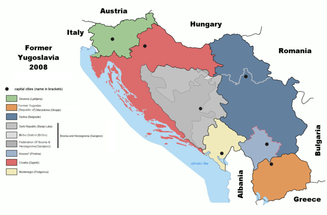
English: Map of former Yugoslavia including Kosovo independence.
Deutsch: Karte des früheren Jugoslawiens einschließlich der Unabhängigkeit des Kosovo. |
| Data | |
| Jatorria | derived from File:Former Yugoslavia 2006.png by Dudemanfellabra at en.wikipedia |
| Egilea | Ijanderson977 |
| Lizentzia (Fitxategi hau berrerabiltzen) |
Released under the GNU Free Documentation License. |
| Beste bertsioak |
|


Transferred from en:wikipedia to Commons by User:Tieum512 using CommonsHelper.
More versions on en.wikipedia see Original upload log below.
Lizentzia

|
Baimena duzu dokumentu hau kopiatu, banatu edo/eta aldatzeko GNU Free Documentation License baldintzapean, Free Software Foundationek argitaratutako 1.2 edo ondorengo bertsioan; sekzio aldaezinik gabe, azaleko testurik gabe, eta atzeko azaleko testurik gabe. Lizentziaren kopia dago GNU Free Documentation License izenburudun atalean. |
| Fitxategi hau Creative Commons Attribution-Share Alike 3.0 Unported lizentziapean dago. | ||
| ||
| This licensing tag was added to this file as part of the GFDL licensing update. |
Jatorrizko igoera erregistroa
The original description page was here. All following user names refer to en.wikipedia.
- 2009-02-19 05:22 Српска Крајина 1887×1192× (131504 bytes)
- 2008-07-06 20:01 Ijanderson977 1887×1192× (130802 bytes) Corrected spelling from Albanian to English.
- 2008-07-04 00:35 Hoshie 1887×1192× (122315 bytes) Give Kosovo own color due to the change in status.
- 2008-03-18 23:43 Dudemanfellabra 1887×1192× (83000 bytes) Map of former Yugoslavia edited to include Kosovo independence. March 2008 Author: Floyd Maseda (Dudemanfellabra). Original image: [http://en.wikipedia.org/wiki/Image:Former_Yugoslavia_2006.png] June 2006 Author: Paweł Goleniowski (swPawel)
Fitxategiaren historia
Data/orduan klik egin fitxategiak orduan zuen itxura ikusteko.
| Data/Ordua | Iruditxoa | Neurriak | Erabiltzailea | Iruzkina | |
|---|---|---|---|---|---|
| oraingoa | 21:12, 26 urria 2022 | | 1.887 × 1.242 (114 KB) | Ghostantinos | fix |
| 23:06, 26 abuztua 2021 |  | 1.887 × 1.242 (105 KB) | Santasa99 | more npov | |
| 15:53, 27 uztaila 2019 |  | 1.887 × 1.242 (95 KB) | Drax90 | New updated version | |
| 21:05, 22 otsaila 2019 |  | 1.887 × 1.192 (136 KB) | Koreanovsky | Reverted to version as of 10:29, 21 February 2019 (UTC) | |
| 14:06, 21 otsaila 2019 |  | 1.887 × 1.242 (95 KB) | Drax90 | New color scheme | |
| 12:29, 21 otsaila 2019 |  | 1.887 × 1.192 (136 KB) | UglyGoat | Reverted to version as of 17:08, 4 February 2019 (UTC) | |
| 19:44, 12 otsaila 2019 |  | 1.887 × 1.242 (95 KB) | Drax90 | Fixed version of the map | |
| 19:08, 4 otsaila 2019 |  | 1.887 × 1.192 (136 KB) | Koreanovsky | There is no official border between Herzeg-Bosnia and FBiH; Reverted to version as of 23:01, 18 December 2011 (UTC) | |
| 18:52, 19 abendua 2018 |  | 1.887 × 1.242 (97 KB) | Drax90 | Latest version with new colors | |
| 20:44, 24 azaroa 2018 |  | 1.887 × 1.242 (149 KB) | Drax90 | Updated version |
Irudira dakarten loturak
Hurrengo orrialdeek dute fitxategi honetarako lotura:
Fitxategiaren erabilera orokorra
Hurrengo beste wikiek fitxategi hau darabilte:
- ar.wikipedia.org proiektuan duen erabilera
- bg.wikipedia.org proiektuan duen erabilera
- ca.wikipedia.org proiektuan duen erabilera
- cs.wikipedia.org proiektuan duen erabilera
- de.wikipedia.org proiektuan duen erabilera
- de.wikibooks.org proiektuan duen erabilera
- el.wikipedia.org proiektuan duen erabilera
- en.wikipedia.org proiektuan duen erabilera
- es.wikipedia.org proiektuan duen erabilera
- fr.wikipedia.org proiektuan duen erabilera
- gd.wikipedia.org proiektuan duen erabilera
- he.wikipedia.org proiektuan duen erabilera
- hyw.wikipedia.org proiektuan duen erabilera
- it.wikipedia.org proiektuan duen erabilera
- ja.wikipedia.org proiektuan duen erabilera
- kn.wikipedia.org proiektuan duen erabilera
- ko.wikipedia.org proiektuan duen erabilera
- lfn.wikipedia.org proiektuan duen erabilera
- mk.wikipedia.org proiektuan duen erabilera
- mr.wikipedia.org proiektuan duen erabilera
- nl.wikipedia.org proiektuan duen erabilera
- pnb.wikipedia.org proiektuan duen erabilera
- pt.wikipedia.org proiektuan duen erabilera
- rm.wikipedia.org proiektuan duen erabilera
- ro.wikipedia.org proiektuan duen erabilera
- ru.wikipedia.org proiektuan duen erabilera
- sh.wikipedia.org proiektuan duen erabilera
- sl.wikipedia.org proiektuan duen erabilera
- sr.wikipedia.org proiektuan duen erabilera
- ta.wikipedia.org proiektuan duen erabilera
- te.wikipedia.org proiektuan duen erabilera
- th.wikipedia.org proiektuan duen erabilera
- tr.wikipedia.org proiektuan duen erabilera
- ur.wikipedia.org proiektuan duen erabilera
Ikus fitxategi honen erabilpen global gehiago.