Fitxategi:Franklin's lost expedition map.png

Orriaren edukia ez da onartzen beste hizkuntza batzuetan.
Wikipedia, Entziklopedia askea

Franklin's_lost_expedition_map.png((602 × 520 pixel, fitxategiaren tamaina: 121 KB, MIME mota: image/png))

Fitxategi hau Wikimedia Commonsekoa da. Hango deskribapen orriko informazioa behean duzu.
Commons gordailu bat da, lizentzia askea duten multimedia fitxategiena. Lagun dezakezu.

Fitxategi hau Wikimedia Commonsekoa da

Laburpena

Deskribapena
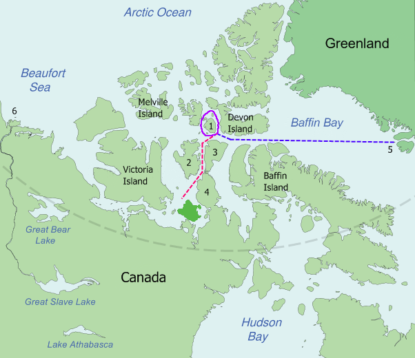
English: Map of the probable routes taken by Erebus and Terror during Franklin's lost expedition.
 
Disko Bay (5) to Beechey Island, in 1845
 
Around Cornwallis Island (1), in 1845
 
Beechey Island down Peel Sound between Prince of Wales Island (2) and Somerset Island (3) and the Boothia Peninsula (4) to near King William Island in 1846
Disko Bay (5) is about 3,200 kilometres (2,000 mi) from the mouth of the MacKenzie River (6).
Español: Mapa de las probables rutas seguidas por los buques Erebus y Terror durante la expedición de Franklin.
 
De la Bahía de Disko (5) a la Isla Beechey, en 1845.
 
Alrededor de la Isla Cornwallis (1), en 1845.
 
Desde la Isla Beechey descienden por el Estrecho de Peel, entre la Isla del Príncipe de Gales (2) y la Isla Somerset (3) y la Península de Boothia (4), hasta aproximarse a la Isla del Rey Guillermo en 1846.
La bahía de Disko (5) se encuentra a 3.200 kilómetros de la desembocadura del río Mackenzie (6).
Data
Jatorria Based on Image:King_William_Island.svg, which is a modification by User:Kennonv of images from the CIA World Fact Book, a U.S. government work in the public domain, further modified by User:Finetooth
Egilea Finetooth, Kennonv, U.S. Central Intelligence Agency
Beste bertsioak

Derivative works of this file:  Franklin's lost expedition map ru.png

Franklin Last Expedition Map.jpg, superseded by this png
Irudi hau birsortu beharko litzateke SVG irudi bektorial moduan. Honek abantaila asko ematen ditu, ikus Commons:Media for cleanup (ingelesez) informazio gehiagorako. Irudi honen SVG bertsioa eskuragarri badago, mesedez Commonsera igo. Igo ostean, ordezkatu txantiloi hau txantiloi honegatik {{vector version available|irudiaren izen berria.svg}} irudi honetan.

Lizentzia

Nik, lan honen egileak, argitaratzen dut ondorengo lizentzia hauen pean:
GNU head Baimena duzu dokumentu hau kopiatu, banatu edo/eta aldatzeko GNU Free Documentation License baldintzapean, Free Software Foundationek argitaratutako 1.2 edo ondorengo bertsioan; sekzio aldaezinik gabe, azaleko testurik gabe, eta atzeko azaleko testurik gabe. Lizentziaren kopia dago GNU Free Documentation License izenburudun atalean.
w:eu:Creative Commons
eskuduntza berdin partekatu
Fitxategi hau Creative Commons Attribution-Share Alike 3.0 Unported lizentziapean dago.
Askea zara:
  • partekatzeko – lana kopiatzeko, banatzeko eta bidaltzeko
  • birnahasteko – lana moldatzeko
Ondorengo baldintzen pean:
  • eskuduntza – Egiletza behar bezala aitortu behar duzu, lizentzia ikusteko esteka gehitu, eta ea aldaketak egin diren aipatu. Era egokian egin behar duzu hori guztia, baina inola ere ez egileak zure lana edo zure erabilera babesten duela irudikatuz.
  • berdin partekatu – Lan honetan oinarrituta edo aldatuta berria eraikitzen baduzu, emaitza lana hau bezalako lizentzia batekin argitaratu behar duzu.
Nahiago duzun lizentzia erabil dezakezu.


Public domain
This image is in the public domain because it contains materials that originally came from the United States Central Intelligence Agency's World Factbook.

Bahasa Indonesia  čeština  Deutsch  eesti  English  español  Esperanto  français  galego  hrvatski  italiano  Nederlands  norsk nynorsk  polski  português  sicilianu  slovenščina  suomi  Türkçe  Zazaki  беларуская (тарашкевіца)  македонски  русский  српски / srpski  українська  ქართული  বাংলা  தமிழ்  മലയാളം  한국어  日本語  中文  中文(简体)  中文(繁體)  العربية  +/−

Irudi-oineko testuak

Add a one-line explanation of what this file represents

Fitxategi honetan agertzen diren itemak

honako hau irudikatzen du

23 uztaila 2008

Fitxategiaren historia

Data/orduan klik egin fitxategiak orduan zuen itxura ikusteko.

Data/OrduaIruditxoaNeurriakErabiltzaileaIruzkina
oraingoa16:52, 6 ekaina 200916:52, 6 ekaina 2009 bertsioaren iruditxoa602 × 520 (121 KB)Like tears in rainTrying to remove border
02:12, 24 uztaila 200802:12, 24 uztaila 2008 bertsioaren iruditxoa668 × 536 (114 KB)Finetooth{{Information |Description={{en|1={{en|Map of the probable routes taken by ''Erebus'' and ''Terror'' during Franklin's lost expedition. {{legend|blue|Disko Bay (5) to Beechey Island, in 1845}} {{legend|purple|Around Cornwallis Island (1), in 1845}} {

Hurrengo orrialdeek dute fitxategi honetarako lotura:

Fitxategiaren erabilera orokorra

Hurrengo beste wikiek fitxategi hau darabilte: