
Fitxategi:International E Road Network green.png

Aurreikuspen honen neurria: 800 × 571 pixel. Bestelako bereizmenak: 320 × 229 pixel | 640 × 457 pixel.
Bereizmen handikoa ((840 × 600 pixel, fitxategiaren tamaina: 38 KB, MIME mota: image/png))
Fitxategi hau Wikimedia Commonsekoa da. Hango deskribapen orriko informazioa behean duzu. |

|
Irudi hau birsortu beharko litzateke SVG irudi bektorial moduan. Honek abantaila asko ematen ditu, ikus Commons:Media for cleanup (ingelesez) informazio gehiagorako. Irudi honen SVG bertsioa eskuragarri badago, mesedez Commonsera igo. Igo ostean, ordezkatu txantiloi hau txantiloi honegatik {{vector version available|irudiaren izen berria.svg}} irudi honetan.
|
Laburpena
| Deskribapena |
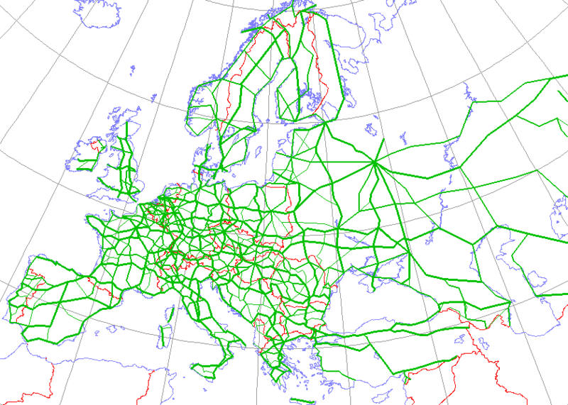
English: Map generated using coastline/boundary data from World Data Bank, and locations from http://www.world-gazetteer.com/. Straight lines connect control cities, no attempt to follow the real road. Roads color has been changed to green.
Deutsch: Diese Karte wurde mit den Küsten- und Grenzverlaufsdaten aus der World Data Bank und mit den Koordinaten aus http://www.world-gazetteer.com/ erstellt. Die Städte sind durch gerade Linien vebunden die nicht unbedingt den realen Straßenverlauf wiedergeben. Die Farbe der Straßen wurde in grün geändert.
Türkçe: Harita oluşturulken sahilyolu ve sınırlar bilgisi Dünya Bilgi Bankası'ndan ve lokasyonlar http://www.world-gazetteer.com/ adlı siteden alınmıştır. Düz çizgiler kontrol şehirlerini bağlar. Yol rengi yeşile değiştirildi. |
| Jatorria | http://en.wikipedia.org/wiki/Image:International_E_Road_Network.png |
| Egilea | Kjhskj75 |
Lizentzia
| Nik, lan honen egile eskubideen jabeak, lan hau domeinu publikoan jartzen dut. Mundu osoan du eragina honek. Estatu batzuetan beharbada hori ez da legez posible izango. Halakoetan: Edonori ematen diot lan hau edozertarako erabiltzeko eskubidea, inolako baldintzarik gabe, legeak nahitaez ezarritako baldintzak izan ezik. |
Fitxategiaren historia
Data/orduan klik egin fitxategiak orduan zuen itxura ikusteko.
| Data/Ordua | Iruditxoa | Neurriak | Erabiltzailea | Iruzkina | |
|---|---|---|---|---|---|
| oraingoa | 18:09, 13 maiatza 2008 | | 840 × 600 (38 KB) | Jklamo | Albania update |
| 14:07, 22 abendua 2007 |  | 840 × 600 (39 KB) | BIL | == Description == {{Information |Description=Map generated using coastline/boundary data from World Data Bank, and locations from www.world-gazetteer.com. Straight lines connect control cities, no attempt to follow the real road. Roads color has been chan | |
| 22:03, 7 urria 2007 |  | 840 × 600 (33 KB) | The RedBurn | All e-roads in green. | |
| 21:55, 7 urria 2007 |  | 840 × 600 (34 KB) | The RedBurn | {{Information |Description=Map generated using coastline/boundary data from World Data Bank, and locations from www.world-gazetteer.com. Straight lines connect control cities, no attempt to follow the real road. Roads color has been changed to green. |Sou |
Irudira dakarten loturak
Hurrengo orrialdeek dute fitxategi honetarako lotura:
Fitxategiaren erabilera orokorra
Hurrengo beste wikiek fitxategi hau darabilte:
- ar.wikipedia.org proiektuan duen erabilera
- be.wikipedia.org proiektuan duen erabilera
- bg.wikipedia.org proiektuan duen erabilera
- Европейски път
- Европейски път Е79
- Европейски път Е70
- Европейски път Е80
- Европейски път Е67
- Европейски път Е85
- Европейски път Е851
- Европейски път Е671
- Шаблон:Европейска пътна мрежа
- Европейски път Е81
- Европейски път Е804
- Европейски път Е763
- Европейски път Е762
- Европейски път Е87
- Европейски път Е772
- Европейски път Е83
- Европейски път Е871
- Европейски път Е75
- Европейски път Е773
- Европейски път Е11
- Европейски път Е51
- Европейски път Е761
- Европейски път Е17
- Европейски път Е76
- Европейски път Е82
- Европейски път Е84
- Европейски път Е86
- Европейски път E01
- Европейски път E03
- Европейски път E04
- Европейски път E05
- Европейски път E06
- Европейски път E07
- Европейски път E08
- Европейски път E09
- Европейски път E10
- Европейски път E12
- Европейски път E13
- Европейски път E14
Ikus fitxategi honen erabilpen global gehiago.