
Fitxategi:Italy 1000 AD.svg

Bereizmen handikoa (SVG fitxategia, nominaldi 565 × 811 pixel, fitxategiaren tamaina: 861 KB)
Fitxategi hau Wikimedia Commonsekoa da. Hango deskribapen orriko informazioa behean duzu. |
Laburpena
| Deskribapena |
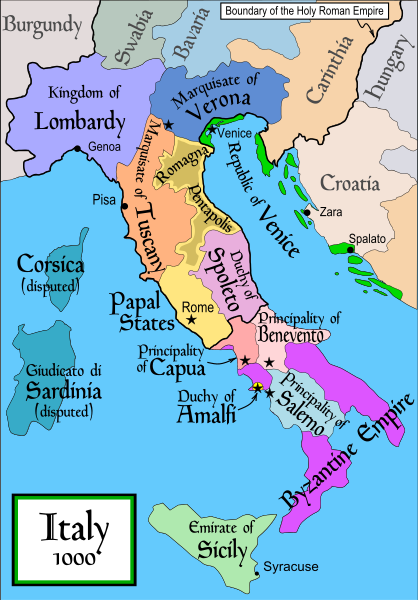
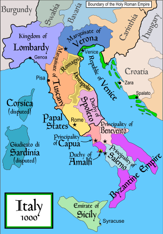
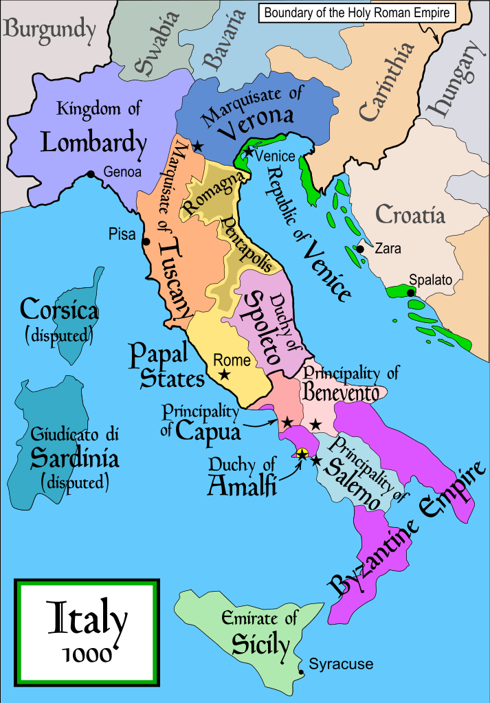
English: Political map of Italy in 1000 AD (CE). Created by MapMaster.
Part of a series of maps on the history of Italy:
|
| Data | 2006ko azaroaren 17a (Jatorrizko igoera-data) |
| Jatorria | No machine-readable source provided. Own work assumed (based on copyright claims). |
| Egilea | No machine-readable author provided. MapMaster assumed (based on copyright claims). |
| Beste bertsioak |
[]
SVG:
PNG:
|


|
SVG fitxategi honek Inkscape edo Adobe Illustrator bezalako SVG editore bat erabiliz erraz itzul daitekeen barneratutako testua du. Argibide gehiago. Nahi izanez gero, fitxategia jaitsi eta testu editore bat erabiliz ere itzul dezakezu. |
References
- Bjorklund, Oddvar; Holmboe, Haakon; Rohr, Anders (1970) Historical Atlas of the World, Barnes & Noble, NY, SBN: 389-00253-4.
- This map from Allyn & Bacon, Longman, textbook publishers.
- This map of the w:en:Holy Roman Empire
- A map from Attilios
- This map of 1050 AD Italy, from the 1923 The Historical Atlas by William R. Shepherd
- This map of 1000 AD Italy from Fordham University, adapted from Muir's Historical Atlas, (1911).
In addition, a number of other sources were consulted in an effort to determine the following matters:
- The extent of Venetian control over the cities of Dalmatia such as Zara and Spalato. Although the Venetians had been pushed off the mainland earlier, in the period around the year 1000, the Venetians made an effort to recover these cities.
- The extent of Saracen control over Corsica and Sardinia. Information is sparse. The apparent situation is that the Muslims had several bases on the coasts of these islands, but did not control the countryside (such as they did in Sicily).
- Whether or not the principalities of Capua and Benevento were separate states in the year 1000. Based on lists of their rulers (various Pandulfs and Landulfs), the answer seems to be "yes".
- Who controlled the Balkans on the southeastern border of the Kingdom of Croatia. Candidates include Bulgaria, the Byzantine Empire, Croatia, and Serbia.
As noted, there is significant disagreement among sources on these questions.
This map was commissioned by Attilios, and there is also a discussion to be found on MapMaster's English talk page.
Lizentzia

|
Baimena duzu dokumentu hau kopiatu, banatu edo/eta aldatzeko GNU Free Documentation License baldintzapean, Free Software Foundationek argitaratutako 1.2 edo ondorengo bertsioan; sekzio aldaezinik gabe, azaleko testurik gabe, eta atzeko azaleko testurik gabe. Lizentziaren kopia dago GNU Free Documentation License izenburudun atalean. |
| Fitxategi hau Creative Commons Attribution-Share Alike 3.0 Unported lizentziapean dago. | ||
| ||
| This licensing tag was added to this file as part of the GFDL licensing update. |
derivative works
Derivative works of this file: Italya MS 1000.svg
Fitxategiaren historia
Data/orduan klik egin fitxategiak orduan zuen itxura ikusteko.
| Data/Ordua | Iruditxoa | Neurriak | Erabiltzailea | Iruzkina | |
|---|---|---|---|---|---|
| oraingoa | 21:50, 17 apirila 2007 | | 565 × 811 (861 KB) | MapMaster | Some further changes |
| 07:10, 19 otsaila 2007 |  | 565 × 811 (824 KB) | MapMaster | changes to ensure consistency with my other Italy maps | |
| 07:39, 25 azaroa 2006 |  | 565 × 811 (823 KB) | MapMaster | Improved map. | |
| 16:44, 18 azaroa 2006 |  | 565 × 811 (827 KB) | MapMaster | Improved (I hope) version based on recommendations from Attilios. | |
| 23:50, 17 azaroa 2006 |  | 565 × 811 (768 KB) | MapMaster | Political map of Italy in 1000 AD (CE). |
Irudira dakarten loturak
Hurrengo orrialdeek dute fitxategi honetarako lotura:
Fitxategiaren erabilera orokorra
Hurrengo beste wikiek fitxategi hau darabilte:
- an.wikipedia.org proiektuan duen erabilera
- ar.wikipedia.org proiektuan duen erabilera
- ast.wikipedia.org proiektuan duen erabilera
- azb.wikipedia.org proiektuan duen erabilera
- az.wikipedia.org proiektuan duen erabilera
- bg.wikipedia.org proiektuan duen erabilera
- bn.wikipedia.org proiektuan duen erabilera
- bs.wikipedia.org proiektuan duen erabilera
- ckb.wikipedia.org proiektuan duen erabilera
- cs.wikipedia.org proiektuan duen erabilera
- da.wikipedia.org proiektuan duen erabilera
- de.wikipedia.org proiektuan duen erabilera
- el.wikipedia.org proiektuan duen erabilera
- en.wikipedia.org proiektuan duen erabilera
- Lombards
- Pope Stephen IX
- Otto III, Holy Roman Emperor
- Otto II, Holy Roman Emperor
- Salerno
- Benevento
- Emirate
- Italian city-states
- List of historical states of Italy
- List of state leaders in the 10th century
- Duchy of Spoleto
- Duchy of Benevento
- Kalbids
- Guaimar IV of Salerno
- Rainulf Drengot
- Duchy of Amalfi
- Emirate of Sicily
- Sergius IV of Naples
Ikus fitxategi honen erabilpen global gehiago.