
Fitxategi:Mongolei-Topografie,Atlas1903.JPG
Bereizmen handikoa ((879 × 725 pixel, fitxategiaren tamaina: 167 KB, MIME mota: image/jpeg))
Fitxategi hau Wikimedia Commonsekoa da. Hango deskribapen orriko informazioa behean duzu. |
| Deskribapena |
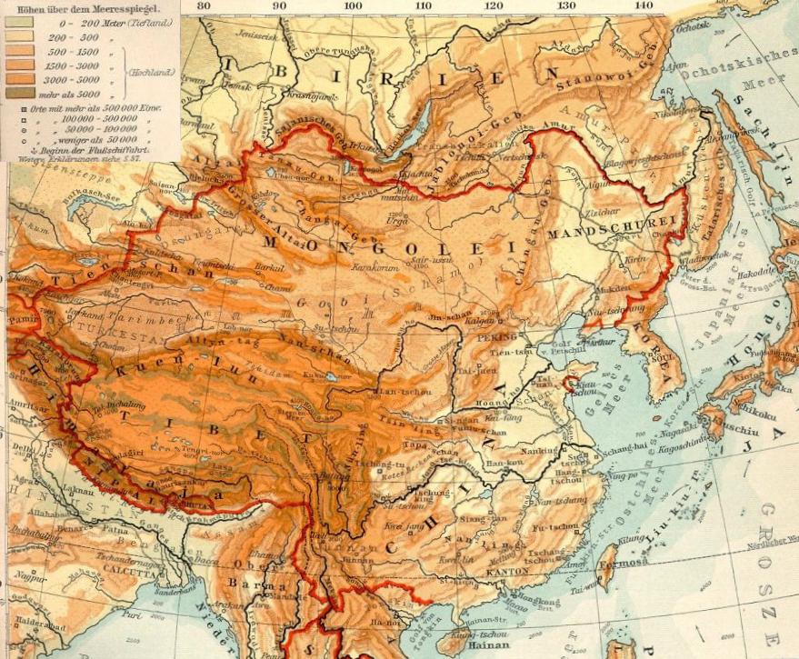
Deutsch: Topografie der Mongolei |
| Data | |
| Jatorria | Transferred from de.wikipedia to Commons. See also Datei:OstasienTopografie.jpg, Ausschnitt aus Verhagen-Atlas 1903) |
| Egilea | Geof (Bearb. +Kartenlegende) |
Lizentzia
|
Lan hau jabetza publikoan dago bai bere jatorrizko herrialdean, bai egile eskubideak egilea hil eta 70 urtera edo gutxiagora iraungitzen diren gainerako herrialdeetan.
| |
| This file has been identified as being free of known restrictions under copyright law, including all related and neighboring rights. | |
Jatorrizko igoera erregistroa
- 2009-03-25 17:12 Geof 871×621× (194656 bytes) {{Information |Beschreibung = Topografie der Mongolei |Quelle = [Datei:OstasienTopografie.jpg], Ausschnitt aus Verhagen-Atlas 1903 |Urheber = Geof (Bearb. +Kartenlegende) |Datum = 25.3.2009 |Andere Versionen = |Anmerkungen = }}
| Annotations | This image is annotated: View the annotations at Commons |
Fitxategiaren historia
Data/orduan klik egin fitxategiak orduan zuen itxura ikusteko.
| Data/Ordua | Iruditxoa | Neurriak | Erabiltzailea | Iruzkina | |
|---|---|---|---|---|---|
| oraingoa | 17:06, 11 urria 2019 | | 879 × 725 (167 KB) | Бмхүн | {{DEFAULTSORT:}} |
| 17:04, 11 urria 2019 |  | 879 × 725 (892 KB) | Бмхүн | {{NAMESPACE}}{{DEFAULTSORT:<languages/><code><nowiki></nowiki></code>}} | |
| 11:23, 15 azaroa 2009 |  | 871 × 621 (190 KB) | Gikü | {{Information |Description={{de|Topografie der Mongolei}} |Source=Transferred from [http://de.wikipedia.org de.wikipedia]. See also de::Datei:OstasienTopografie.jpg, Ausschnitt aus Verhagen-Atlas 1903'') |Date={{Date|2009|03|25}} |Author=Geof (Bearb |
Irudira dakarten loturak
Hurrengo orrialdeek dute fitxategi honetarako lotura:
Fitxategiaren erabilera orokorra
Hurrengo beste wikiek fitxategi hau darabilte:
- ba.wikipedia.org proiektuan duen erabilera
- bn.wikipedia.org proiektuan duen erabilera
- ca.wikipedia.org proiektuan duen erabilera
- cs.wikipedia.org proiektuan duen erabilera
- de.wikipedia.org proiektuan duen erabilera
- el.wikipedia.org proiektuan duen erabilera
- en.wikipedia.org proiektuan duen erabilera
- eo.wikipedia.org proiektuan duen erabilera
- es.wikipedia.org proiektuan duen erabilera
- fa.wikipedia.org proiektuan duen erabilera
- fi.wikipedia.org proiektuan duen erabilera
- gl.wikipedia.org proiektuan duen erabilera
- hr.wikipedia.org proiektuan duen erabilera
- it.wikipedia.org proiektuan duen erabilera
- ml.wikipedia.org proiektuan duen erabilera
- mn.wikipedia.org proiektuan duen erabilera
- no.wikipedia.org proiektuan duen erabilera
- ro.wikipedia.org proiektuan duen erabilera
- sl.wikipedia.org proiektuan duen erabilera
- sr.wikipedia.org proiektuan duen erabilera
- sw.wikipedia.org proiektuan duen erabilera
- tr.wikipedia.org proiektuan duen erabilera
- www.wikidata.org proiektuan duen erabilera
- zh.wikipedia.org proiektuan duen erabilera