
Fitxategi:Schengenzone.svg

SVG fitxategi honen PNG aurreikuspenaren tamaina: 560 × 599 pixel. Bestelako bereizmenak: 224 × 240 pixel | 449 × 480 pixel | 718 × 768 pixel | 957 × 1.024 pixel | 1.914 × 2.048 pixel | 645 × 690 pixel.
Bereizmen handikoa (SVG fitxategia, nominaldi 645 × 690 pixel, fitxategiaren tamaina: 358 KB)
Fitxategi hau Wikimedia Commonsekoa da. Hango deskribapen orriko informazioa behean duzu. |
Laburpena
| Deskribapena |
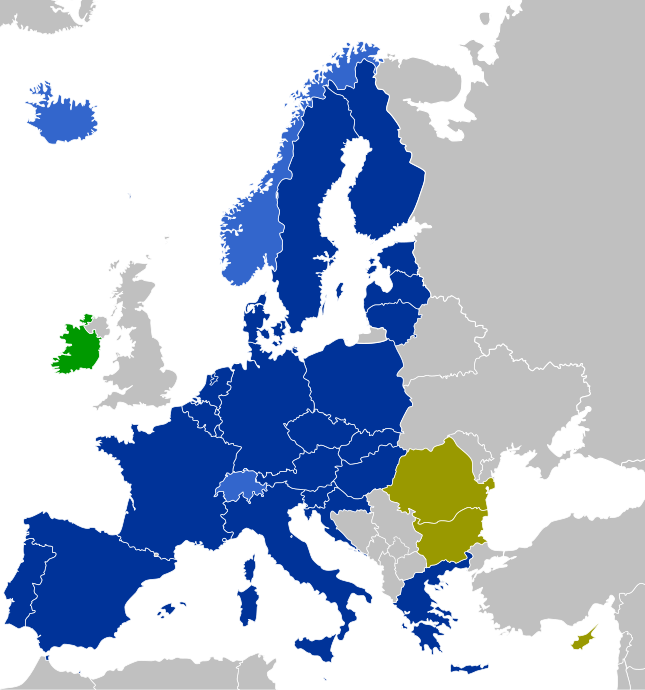
Navy: Fully participating Schengen members (EU member states which have implemented the Schengen Agreement)
Blue: Associated Schengen members (non-EU member states which have implemented the Schengen Agreement)
Purple: Members of the Schengen Area (air and maritime borders only)
Olive: Other EU member states (EU member states which have not implemented the Schengen Agreement)
Green: States which apply only some Schengen laws |
| Data | |
| Jatorria | Norberak egina |
| Egilea | CrazyPhunk |
| Beste bertsioak | There is similar map Schengen Area participation.svg existing. |
| SVG genesis | Fitxategi hau (bektore-irudia) hau Inkscape-ekin sortu da .
. |
Lizentzia
| Nik, lan honen egile eskubideen jabeak, lan hau domeinu publikoan jartzen dut. Mundu osoan du eragina honek. Estatu batzuetan beharbada hori ez da legez posible izango. Halakoetan: Edonori ematen diot lan hau edozertarako erabiltzeko eskubidea, inolako baldintzarik gabe, legeak nahitaez ezarritako baldintzak izan ezik. |
Fitxategiaren historia
Data/orduan klik egin fitxategiak orduan zuen itxura ikusteko.
| Data/Ordua | Iruditxoa | Neurriak | Erabiltzailea | Iruzkina | |
|---|---|---|---|---|---|
| oraingoa | 15:01, 2 urtarrila 2023 | | 645 × 690 (358 KB) | Iktsokh | Correction of borders |
| 02:43, 1 urtarrila 2023 |  | 645 × 690 (478 KB) | Kamran.nef | Added Croatia | |
| 21:22, 9 ekaina 2021 |  | 645 × 690 (477 KB) | Geo.smart | Reverted to version as of 13:12, 1 January 2021 (UTC) UK is a part of neither EU nor the Schengenzone | |
| 20:26, 2 urtarrila 2021 |  | 645 × 690 (477 KB) | Opihuck | Reverted to version as of 23:02, 4 February 2020 (UTC) | |
| 15:12, 1 urtarrila 2021 |  | 645 × 690 (477 KB) | Ärrännä | Reverted to version as of 01:32, 1 February 2020 (UTC) because now United Kingdom is not anymore part of EU | |
| 01:02, 5 otsaila 2020 |  | 645 × 690 (477 KB) | Opihuck | Reverted to version as of 21:43, 20 February 2017 (UTC) - GB und IRL continue to be associated at least until end of 2020 | |
| 03:32, 1 otsaila 2020 |  | 645 × 690 (477 KB) | Tohaomg | Brexit | |
| 23:43, 20 otsaila 2017 |  | 645 × 690 (477 KB) | Nablicus | lakes removed | |
| 14:23, 21 abuztua 2015 |  | 645 × 690 (526 KB) | DaB. | Lakes, no Boarders. | |
| 09:38, 16 azaroa 2014 |  | 645 × 690 (531 KB) | Nablicus | Reverted to version as of 10:13, 30 June 2013. Romania and Bulgaria have not implemented all parts of the Schengen aquis |
Irudira dakarten loturak
Hurrengo orrialdeek dute fitxategi honetarako lotura:
Fitxategiaren erabilera orokorra
Hurrengo beste wikiek fitxategi hau darabilte:
- af.wikipedia.org proiektuan duen erabilera
- als.wikipedia.org proiektuan duen erabilera
- ar.wikipedia.org proiektuan duen erabilera
- arz.wikipedia.org proiektuan duen erabilera
- bg.wikipedia.org proiektuan duen erabilera
- bn.wikipedia.org proiektuan duen erabilera
- ca.wikipedia.org proiektuan duen erabilera
- cs.wikipedia.org proiektuan duen erabilera
- de.wikipedia.org proiektuan duen erabilera
- Schengener Abkommen
- Schengener Informationssystem
- Dezember 2008
- Dezember 2011
- Wikipedia:Kartenwerkstatt/Archiv/2011-05
- Verordnung (EG) Nr. 539/2001 (EU-Visum-Verordnung)
- Verordnung (EU) 2016/399 (Schengener Grenzkodex)
- Diskussion:Flüchtlingskrise in Europa 2015/2016/Archiv/2
- Verordnung (EG) Nr. 810/2009 (Visakodex)
- Benutzer:Tmid
- Portal:Migration und Integration/Artikel des Monats
- Einreise-/Ausreisesystem
- Europäisches Reiseinformations- und ‑genehmigungssystem
- Benutzer:Opihuck/Verordnung (EG) Nr. 539/2001 (EU-Visum-Verordnung)
- Extrempunkte der Europäischen Union
- Benutzer:Kpfiwa/Spielwiese/Test
- Benutzer:Valo139
- Benutzer:Wandelndes Lexikon/alt
- Benutzer:Wandelndes Lexikon/Babel
- Benutzer:Wandelndes Lexikon/Babel/Schengen-Raum
- Benutzer:Wandelndes Lexikon/Babel-Block/Herkunft
- Benutzer:Wandelndes Lexikon/Babel-Block
- Benutzer:Wandelndes Lexikon
- de.wikibooks.org proiektuan duen erabilera
- de.wikinews.org proiektuan duen erabilera
- en.wikipedia.org proiektuan duen erabilera
- en.wikibooks.org proiektuan duen erabilera
- en.wikinews.org proiektuan duen erabilera
- es.wikipedia.org proiektuan duen erabilera
- fi.wikipedia.org proiektuan duen erabilera
- fr.wikipedia.org proiektuan duen erabilera
- fr.wikinews.org proiektuan duen erabilera
Ikus fitxategi honen erabilpen global gehiago.