
Fitxategi:WorldCenterOfPopulation.png
Aurreikuspen honen neurria: 800 × 493 pixel. Bestelako bereizmenak: 320 × 197 pixel | 640 × 394 pixel | 1.073 × 661 pixel.
Bereizmen handikoa ((1.073 × 661 pixel, fitxategiaren tamaina: 141 KB, MIME mota: image/png))
Fitxategi hau Wikimedia Commonsekoa da. Hango deskribapen orriko informazioa behean duzu. |
Laburpena
| Deskribapena |
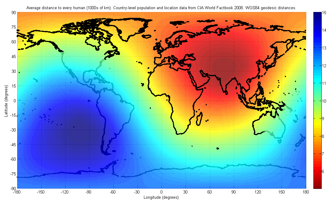
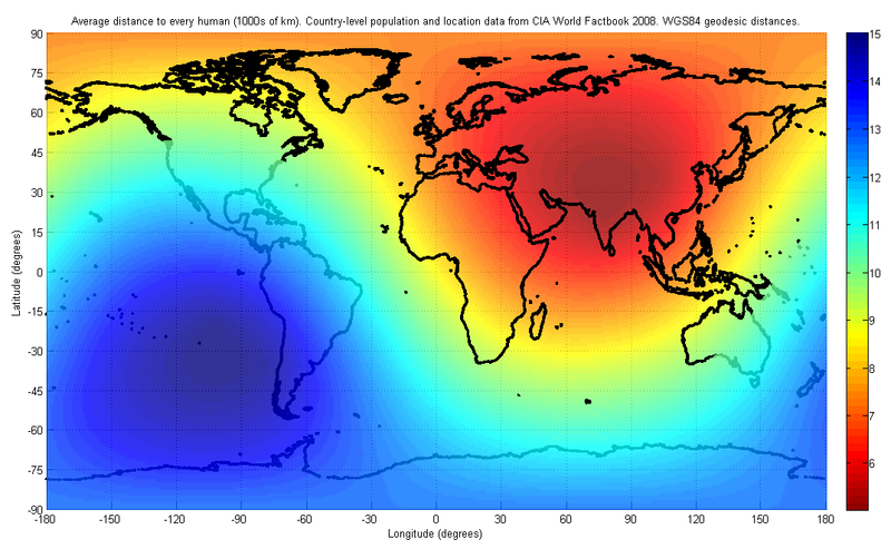
English: The figure indicates the average distance to every human on earth, depending on location. The population and location data used are at the country-level, from the 2008 CIA World Factbook. The distance was computed first by finding the geodesic (shortest path) distance along the surface of the WGS84 reference ellipsoid to each country on the list, and then finding the weighted average of all such distances with the weight being the corresponding country's population.
I have used only publicly available data for this image. The image may look slightly different in future, as world population distributions change. The image will also look different if a different distance metric is used, such as a Euclidean distance in three dimensions, which would allow for tunneling through the earth. |
| Data | |
| Jatorria | Norberak egina |
| Egilea | Brhaspati |
Lizentzia
Nik, lan honen egileak, argitaratzen dut ondorengo lizentzia hauen pean:
Fitxategi hau Creative Commons Attribution-Share Alike 3.0 Unported lizentziapean dago.
- Askea zara:
- partekatzeko – lana kopiatzeko, banatzeko eta bidaltzeko
- birnahasteko – lana moldatzeko
- Ondorengo baldintzen pean:
- eskuduntza – Egiletza behar bezala aitortu behar duzu, lizentzia ikusteko esteka gehitu, eta ea aldaketak egin diren aipatu. Era egokian egin behar duzu hori guztia, baina inola ere ez egileak zure lana edo zure erabilera babesten duela irudikatuz.
- berdin partekatu – Lan honetan oinarrituta edo aldatuta berria eraikitzen baduzu, emaitza lana hau bezalako lizentzia batekin argitaratu behar duzu.

|
Baimena duzu dokumentu hau kopiatu, banatu edo/eta aldatzeko GNU Free Documentation License baldintzapean, Free Software Foundationek argitaratutako 1.2 edo ondorengo bertsioan; sekzio aldaezinik gabe, azaleko testurik gabe, eta atzeko azaleko testurik gabe. Lizentziaren kopia dago GNU Free Documentation License izenburudun atalean. |
Nahiago duzun lizentzia erabil dezakezu.
Fitxategiaren historia
Data/orduan klik egin fitxategiak orduan zuen itxura ikusteko.
| Data/Ordua | Iruditxoa | Neurriak | Erabiltzailea | Iruzkina | |
|---|---|---|---|---|---|
| oraingoa | 20:52, 4 abendua 2021 | | 1.073 × 661 (141 KB) | JIP | Inverted colour hues. Now red means more population density and blue means less. |
| 01:11, 3 ekaina 2008 |  | 1.073 × 661 (144 KB) | Brhaspati | {{Information |Description={{en|1=The figure indicates the average distance to every human on earth, depending on location. The population and location data used are at the country-level, from the 2008 CIA World Factbook. The distance was computed first b |
Irudira dakarten loturak
Hurrengo orrialdeek dute fitxategi honetarako lotura:
Fitxategiaren erabilera orokorra
Hurrengo beste wikiek fitxategi hau darabilte:
- de.wikipedia.org proiektuan duen erabilera
- en.wikipedia.org proiektuan duen erabilera
- ja.wikipedia.org proiektuan duen erabilera
- ru.wikipedia.org proiektuan duen erabilera
- uk.wikipedia.org proiektuan duen erabilera