
Fitxategi:World Köppen Map.jpg

Aurreikuspen honen neurria: 800 × 530 pixel. Bestelako bereizmenak: 320 × 212 pixel | 640 × 424 pixel | 1.024 × 679 pixel | 1.280 × 848 pixel | 2.560 × 1.697 pixel | 4.231 × 2.804 pixel.
Bereizmen handikoa ((4.231 × 2.804 pixel, fitxategiaren tamaina: 1,25 MB, MIME mota: image/jpeg))
Fitxategi hau Wikimedia Commonsekoa da. Hango deskribapen orriko informazioa behean duzu. |

|
Irudi hau birsortu beharko litzateke SVG irudi bektorial moduan. Honek abantaila asko ematen ditu, ikus Commons:Media for cleanup (ingelesez) informazio gehiagorako. Irudi honen SVG bertsioa eskuragarri badago, mesedez Commonsera igo. Igo ostean, ordezkatu txantiloi hau txantiloi honegatik {{vector version available|irudiaren izen berria.svg}} irudi honetan.
|


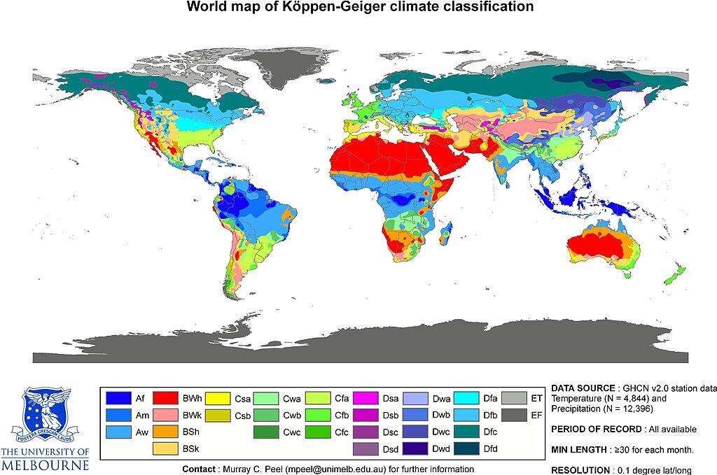
| Peel, M. C. and Finlayson, B. L. and McMahon, T. A. (2007). "Updated world map of the Köppen-Geiger climate classification". Hydrol. Earth Syst. Sci. 11: 1633-1644. ISSN 1027-5606. |
- This is the original JPG-file that is only uploaded as a reference. Please see/use the smaller PNG-file for thumbnailing etc...
Laburpena
| Deskribapena | Updated world map of the Köppen-Geiger climate classification. |
| Data | |
| Jatorria | Hydrology and Earth System Sciences: "Updated world map of the Köppen-Geiger climate classification" (Supplement). |
| Egilea |
Peel, M. C., Finlayson, B. L., and McMahon, T. A. (University of Melbourne) |
| Lizentzia (Fitxategi hau berrerabiltzen) |
See Image:World Köppen Map.png for an improved map to use on Wikipedia and such.
Lizentzia
This file is licensed under the Creative Commons Attribution-Share Alike 2.5 Generic license.
- Askea zara:
- partekatzeko – lana kopiatzeko, banatzeko eta bidaltzeko
- birnahasteko – lana moldatzeko
- Ondorengo baldintzen pean:
- eskuduntza – Egiletza behar bezala aitortu behar duzu, lizentzia ikusteko esteka gehitu, eta ea aldaketak egin diren aipatu. Era egokian egin behar duzu hori guztia, baina inola ere ez egileak zure lana edo zure erabilera babesten duela irudikatuz.
- berdin partekatu – Lan honetan oinarrituta edo aldatuta berria eraikitzen baduzu, emaitza lana hau bezalako lizentzia batekin argitaratu behar duzu.
Fitxategiaren historia
Data/orduan klik egin fitxategiak orduan zuen itxura ikusteko.
| Data/Ordua | Iruditxoa | Neurriak | Erabiltzailea | Iruzkina | |
|---|---|---|---|---|---|
| oraingoa | 18:55, 20 otsaila 2018 | | 4.231 × 2.804 (1,25 MB) | Maphobbyist | The Caspian coastal lowland of Iran has a humid subtropical climate (Köppen classification: Cfa). The Costa Rican Central Valley has a dry winter oceanic climate (Köppen classification: Cwb). |
| 18:35, 4 apirila 2011 |  | 4.231 × 2.804 (808 KB) | Maphobbyist | Köppen system is based on the concept that climate types are correlated with the natural vegetation. Large bodies of water such as seas (in this case Caspian Sea) are excluded. | |
| 08:40, 1 apirila 2011 |  | 6.708 × 4.443 (4,73 MB) | Bidgee | Reverted to version as of 22:42, 12 October 2007 (Please don't override images) | |
| 14:09, 13 martxoa 2011 |  | 4.231 × 2.804 (809 KB) | Maphobbyist | Slight improvement in image quality as is possible for jpg files. Painted the Caspian Sea as white, because the Köppen system is based on the concept that climate types are correlated with the natural vegetation. Thus with Köppen, climate zone boundarie | |
| 00:42, 13 urria 2007 |  | 6.708 × 4.443 (4,73 MB) | Jeroen | Citation: '''Peel, M. C., Finlayson, B. L., and McMahon, T. A.: Updated world map of the Köppen-Geiger climate classification, Hydrol. Earth Syst. Sci., 11, 1633-1644, 2007.''' :This is the original JPG-file that is only uploaded as a reference. Please |
Irudira dakarten loturak
Ez dago fitxategi hau darabilen orririk.
Fitxategiaren erabilera orokorra
Hurrengo beste wikiek fitxategi hau darabilte:
- en.wikipedia.org proiektuan duen erabilera
- fa.wikipedia.org proiektuan duen erabilera
- he.wikipedia.org proiektuan duen erabilera
- pl.wikipedia.org proiektuan duen erabilera
- sco.wikipedia.org proiektuan duen erabilera
- vi.wikipedia.org proiektuan duen erabilera