
Fitxategi:Abbasid Caliphate most extant.png
Ez dago bereizmen handiagorik.
Abbasid_Caliphate_most_extant.png ((800 × 487 pixel, fitxategiaren tamaina: 85 KB, MIME mota: image/png))
Fitxategi hau Wikimedia Commonsekoa da. Hango deskribapen orriko informazioa behean duzu. |
| Deskribapena |
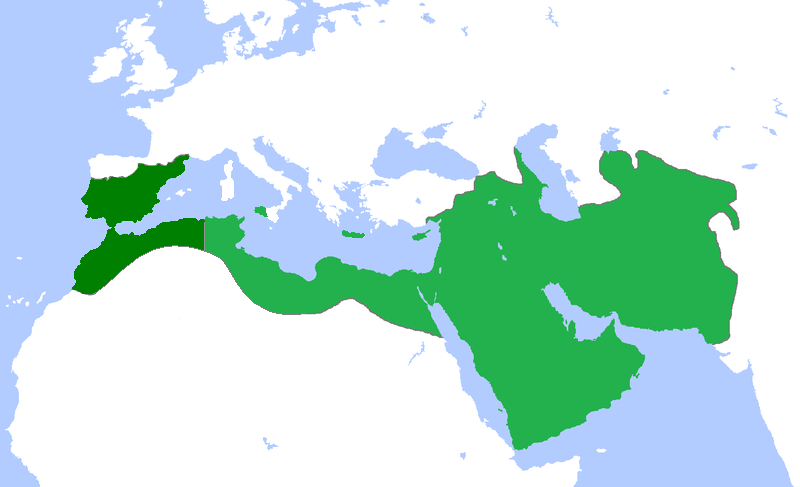
English: Locator map for the Abbasid Caliphate at its greatest extent, before the independence of al-Maghrib (Morocco and parts of Algeria) in 744 as well as al-Andalus (Spain and Portugal) 7yghfjs560the in the early 333 |
| Data | (UTC) |
| Jatorria | |
| Egilea |
|
| This is a retouched picture, which means that it has been digitally altered from its original version. Modifications: seperated the parts that gained independance from the Abbasid Caliphate. The original can be viewed here: Umayyad750ADloc.png:
|
Nik, lan honen egileak, argitaratzen dut ondorengo lizentzia pean:
Fitxategi hau Creative Commons Aitortu 3.0 Unported lizentziaren mende dago.
- Askea zara:
- partekatzeko – lana kopiatzeko, banatzeko eta bidaltzeko
- birnahasteko – lana moldatzeko
- Ondorengo baldintzen pean:
- eskuduntza – Egiletza behar bezala aitortu behar duzu, lizentzia ikusteko esteka gehitu, eta ea aldaketak egin diren aipatu. Era egokian egin behar duzu hori guztia, baina inola ere ez egileak zure lana edo zure erabilera babesten duela irudikatuz.
Jatorrizko igoera erregistroa
This image is a derivative work of the following images:
- File:Umayyad750ADloc.png licensed with Cc-by-3.0
- 2009-04-22T16:17:51Z Gabagool 1481x902 (51495 Bytes) some corrections..
- 2009-04-20T16:10:54Z Gabagool 1481x902 (51573 Bytes) {{Information |Description={{en|1=Locator map for the Umayyad Caliphate at its greatest extent, c. AD 750. (Partially based on ''Atlas of World History'' (2007) - World 500-750, map.)}} |Source=Own work by uploader |Author=[
Uploaded with derivativeFX
Fitxategiaren historia
Data/orduan klik egin fitxategiak orduan zuen itxura ikusteko.
| Data/Ordua | Iruditxoa | Neurriak | Erabiltzailea | Iruzkina | |
|---|---|---|---|---|---|
| oraingoa | 20:50, 13 apirila 2013 | | 800 × 487 (85 KB) | Fry1989 | vandalism |
| 18:01, 13 apirila 2013 |  | 800 × 487 (87 KB) | Mouh2jijel | Reverted to version as of 08:30, 13 April 2013 | |
| 16:32, 13 apirila 2013 |  | 800 × 487 (85 KB) | Omar-toons | Reverted to version as of 23:40, 15 November 2012 rv unjustified revert | |
| 10:30, 13 apirila 2013 |  | 800 × 487 (87 KB) | Mouh2jijel | Reverted to version as of 18:50, 8 April 2013 | |
| 08:18, 13 apirila 2013 |  | 800 × 487 (85 KB) | Omar-toons | Reverted to version as of 23:40, 15 November 2012 unjustified revert | |
| 20:50, 8 apirila 2013 |  | 800 × 487 (87 KB) | Mouh2jijel | Reverted to version as of 17:29, 24 April 2012 | |
| 01:40, 16 azaroa 2012 |  | 800 × 487 (85 KB) | Omar-toons | moving southern Ifriqiyan limits a little bit to the north | |
| 19:29, 24 apirila 2012 |  | 800 × 487 (87 KB) | Cplakidas | corrections: Sardinia and Corsica were never taken, and Sicily was not completely conquered until the 870s | |
| 21:11, 25 apirila 2011 |  | 800 × 487 (87 KB) | باسم | added a few Mediterranean islands | |
| 20:12, 25 apirila 2011 |  | 800 × 487 (87 KB) | باسم | {{Information |Description={{en|1=Locator map for the Abbasid Caliphate at its greatest extent, before the independence of al maghrib (morocco and parts of algeria) as well as al andalus (Spain and Portugal)}} |Source=*File:Umayyad750ADloc.png |Date |
Irudira dakarten loturak
Hurrengo orrialdeek dute fitxategi honetarako lotura:
Fitxategiaren erabilera orokorra
Hurrengo beste wikiek fitxategi hau darabilte:
- ar.wikipedia.org proiektuan duen erabilera
- العراق
- بغداد
- تاريخ العراق
- البصرة
- تاريخ إسلامي
- خلافة إسلامية
- الدولة العباسية
- غامد
- برامكة
- بوابة:الإسلام
- قائمة الخلفاء
- بوابة:الإسلام/مقالة مختارة
- تاريخ اليمن الإسلامي
- بوابة:الإمبراطورية الروسية
- بوابة:الإمبراطورية الروسية/بوابات شقيقة
- ويكيبيديا:مقالة الصفحة الرئيسية المختارة/152
- خالد بن برمك
- الممالك في إفريقيا قبل الاستعمار
- يحيى البرمكي
- بوابة:مكة/مقالة مختارة/أرشيف
- بوابة:مكة/مقالة مختارة/10
- بوابة:الأديان/تاريخ ديني
- بوابة:الإسلام/دولة مختارة
- بوابة:الإسلام/دولة مختارة/3
- بوابة:العراق/مقالة مختارة/أرشيف
- بوابة:العراق/مقالة مختارة/2
- بوابة:التاريخ الإسلامي/مقالة مختارة/أرشيف
- مستخدم:باحث
- بوابة:التاريخ/فقرات منوعة/3
- بوابة:التاريخ/فقرات منوعة/أرشيف
- بوابة:التاريخ الإسلامي/دولة مختارة/أرشيف
- بوابة:الإمبراطورية الألمانية
- بوابة:الإمبراطورية الألمانية/بوابات شقيقة
- بوابة:إمبراطورية اليابان
- بوابة:إمبراطورية اليابان/بوابات شقيقة
- بوابة:الخلافة الراشدة
- بوابة:الدولة الأموية
- ويكيبيديا:قائمة اليوم المختارة/يوليو 2015
- بوابة:التاريخ الإسلامي/دولة مختارة/4
- قالب:قائمة اليوم المختارة/2015-07-04
- بوابة:الإمبراطورية الفرنسية الأولى/بوابات شقيقة
- بوابة:الإمبراطورية الفرنسية الأولى
- بوابة:الإمبراطورية النمساوية/بوابات شقيقة
- بوابة:الإمبراطورية النمساوية
- بوابة:العالم الإسلامي
- قالب:مواضيع متعلقة 3
- قالب:مواضيع متعلقة 3/شرح
- بوابة:العالم الإسلامي/تاريخ
- بوابة:العالم الإسلامي/مواضيع متعلقة
- بوابة:الدولة العباسية/واجهة
Ikus fitxategi honen erabilpen global gehiago.